 The Meteorological Service last evening placed Jamaica on a tropical storm warning, saying that the island is now expected to be outside the range of hurricane-force winds associated with Hurricane Matthew, but likely to experience tropical storm conditions.
“This means that tropical storm conditions, including possible sustained wind speeds of 63-118 km/h (39-73 mph), are expected to affect Jamaica in 36 hours or less,” the Met Service said in its 5 p.m. bulletin.
The downgrade from a hurricane warning came after Jamaicans spent five days preparing for the cyclone that at one point grew to Category Five strength as it slow-marched across the central Caribbean.
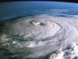
The Met Service said that Matthew remained a Category Four hurricane with maximum sustained winds near 220 km/h (140 mph) and was expected to remain a powerful hurricane through to tomorrow.
“At 4 p.m. [yesterday] the center of Hurricane Matthew was located near latitude 16.3 degrees north, longitude 74.7 degrees west. This is about 305 kilometers (190 miles) south-east of Kingston, Jamaica, or 360 kilometers (225 miles) south-west of Port-au-Prince, Haiti,” the Met Service said.
“Matthew is moving toward the north near 11 km/h (7 mph) and this general motion is expected to continue through Tuesday night, with a turn toward the north-northwest forecast for Wednesday,” the Met Service said.
It added that on this track, the center of Matthew was forecast to approach southwestern Haiti last night and move near eastern Cuba late today.
The Met Service explained that with hurricane-force winds extending outward up to 65 km (40 miles) from the center and tropical storm-force winds extending outward up to 295 km (185 miles), storm-force winds are likely to spread over Jamaica’s eastern parishes, including St. Mary, Portland, St. Thomas, Kingston, St. Andrew and St. Catherine, while gusty winds reaching near tropical storm force should also be expected over central parishes.
Doppler radar, the Met Service said, confirmed that light to moderate showers had already begun to affect mainly northeastern and central sections of the island. However, an extensive area of rainfall offshore was positioned to move over the country last evening and last night.
The forecasters predicted five to 10 inches of rainfall over eastern parishes, as well as storm surges of two to four feet as Matthew passed close to the island last night and today.
Read more here.